


le moulin de la rode

jeanic63
User

Length
12.3 km

Max alt
919 m

Uphill gradient
363 m
Km-Effort
17.1 km

Min alt
735 m

Downhill gradient
360 m
Boucle
Yes
Creation date :
2019-09-12 11:58:42.561
Updated on :
2019-09-12 18:58:29.285
3h23
Difficulty : Easy

FREE GPS app for hiking
 SityTrail
IGN / Geographical institutes
SityTrail Plus
The world is yours!
About
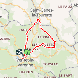
Trail Walking of 12.3 km to be discovered at Auvergne-Rhône-Alpes, Puy-de-Dôme, Le Vernet-Chaméane. This trail is proposed by jeanic63.
Description
départ centre bourg au vernet la ovarienne 63 puy de dôme
Positioning
Country:
France
Region :
Auvergne-Rhône-Alpes
Department/Province :
Puy-de-Dôme
Municipality :
Le Vernet-Chaméane
Location:
Unknown
Start:(Dec)
Start:(UTM)
535210 ; 5035718 (31T) N.
Comments